
News
Tornado chances for Kentucky and Indiana Tuesday
Stay weather aware Tuesday and have at least two ways to receive severe weather alerts if one is issued for your area. All modes of severe weather are possible.
LOUISVILLE, Ky. — After a round of severe thunderstorms barreled through Kentucky and southern Indiana Tuesday morning, another round of severe weather has its sights set on the region this afternoon.
There are no more tornado warnings in the Kentucky, southern Indiana area at the moment, however several Kentucky and Indiana counties remain under a tornado watch.
A Tornado Watch has been issued for numerous counties in the WHAS11 viewing area until 10 p.m.
The WHAS11 First Alert StormTeam is tracking the storm live right now as it makes its way through the region.
Current alerts
A Tornado Watch has been issued for Kentucky and Indiana until 10 p.m. Tuesday night.
Stay off the roads if possible. Have a plan if a tornado warning pops up in your neighborhood.

A tornado watch means conditions are favorable for the development of severe storms, capable of producing tornadoes. Have a plan and be prepared to seek shelter if a warning is issued for your area.
RELATED: Tornado Watch vs. Tornado Warning: What’s the difference?
RELATED: Several Kentucky counties remain under a tornado watch following brief round of storms
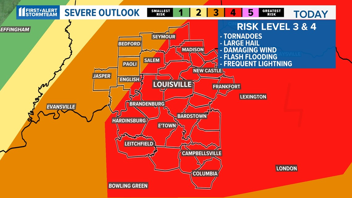
Severe weather risk
Much of the greater Louisville area is under a moderate risk for severe weather this afternoon. This is a level 4 of 5 on the severe weather potential scale issued by the Storm Prediction Center. Kentuckiana has not been under this great of a risk in six years. Take the risk seriously.


If a tornado warning is issued for any county in the viewing area, you can watch live coverage from WHAS11 meteorologists on WHAS11.com, WHAS11+ and the WHAS11 YouTube channel.
RELATED: PHOTOS: Storm damage reported across Kentucky, southern Indiana
Timing
The greatest tornado threat is now until 8 p.m. Tuesday, but tornadoes can occur anywhere at anytime. As storms known as supercells form individually, that is when they are most likely to form tornadoes. But today’s storms will form very quickly and will be responsible for all types of severe weather.
In addition to the tornado threat, large hail, damaging wind and frequent lightning will be possible with any storm that develops. One thing to note is that tornadoes and storms will move rather quickly today. It is very important you act quickly when a severe thunderstorm warning or tornado warning is issued for your area.
Please make sure you charge all appliances and smart phones, have a flashlight and plenty of blankets, food stored and bottled water in the event you lose power today.


A variable that meteorologists use to find storm energy is to look at a variable called CAPE. Take a look at these high values of CAPE that are projected to affect central Kentucky and southern Indiana this afternoon:


Severe weather tips
It is a good idea to familiarize yourself with the severe weather safety tips so that YOU are prepared when Mother Nature produces destructive and at times life-threatening thunderstorms.


Windy, cold air behind system
Model forecasts are also hinting at a cooler than normal pattern throughout the late stages of the week. Temperatures Wednesday through Friday will likely be in the lower to middle 50s.
Overnight temperatures will come close to freezing, if not dipping slightly below freezing, in several locations. This may cause some harm to blooming plants.
We are also tracking strong wind for a few days after the storm marches east of us. The strong cold front will bring in wind gusts out of the west to northwest howling around 25-35 mph, if not greater in some rural spots.
Please take note of this if you drive a high-profile vehicle or have some outdoor furniture that may easily blow around in the wind. The wind will finally begin to taper off during the nighttime hours Thursday.
-

 News2 weeks ago
Rep. Bennie Thompson fires staffer after controversial posts over Trump attack
-

 News4 weeks ago
‘The God of the Woods,’ by Liz Moore book review
-

 News4 weeks ago
The current GC standings at the Tour de France 2024
-

 News4 weeks ago
Mexico vs. Venezuela prediction, odds, start time: 2024 Copa America picks, June 26 bets by soccer expert
-

 News4 weeks ago
Russell wins Austrian Grand Prix after late Verstappen-Norris collision | Motorsports News
-

 News2 weeks ago
Duck Donuts brings back Shark Dozen deal during Shark Week
-

 News4 weeks ago
Rep. Thomas Massie shares about wife Rhonda’s death
-

 News4 weeks ago
Kamala Harris acknowledges Biden had a ‘slow start’ in debate – NBC4 Washington